Digital mapping has emerged as a game-changer, revolutionizing the way projects are planned, executed, and managed. Gone are the days of relying solely on paper blueprints and manual surveys. Today, construction professionals are harnessing the power of digital mapping technologies to streamline processes, enhance decision-making, and optimize project outcomes. In this blog post, we’ll explore the significance of digital mapping in the construction industry and its transformative impact on the built environment.
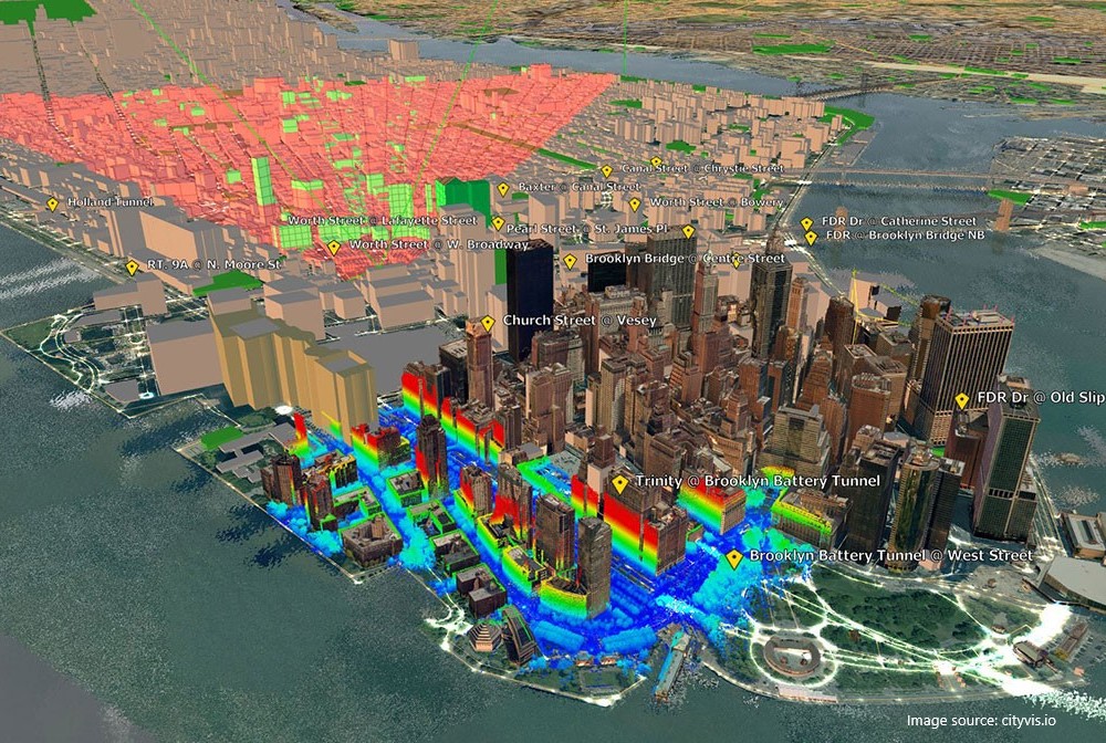
At the heart of digital mapping in construction lies Geographic Information Systems (GIS), a powerful tool that integrates spatial data with advanced analytics to visualize, analyse, and interpret information about the built and natural environment. GIS enables construction professionals to create detailed maps, generate 3D models, and perform spatial analysis to gain insights into project sites, topography, infrastructure networks, and environmental factors. By leveraging GIS, construction companies can make informed decisions regarding site selection, land use planning, and resource allocation, ultimately optimizing project efficiency and minimizing risks.
One of the key applications of digital mapping in construction is site surveying and reconnaissance. Traditional surveying methods often involve time-consuming and labour-intensive processes, such as manual measurements and land surveys. Digital mapping technologies, such as LiDAR (Light Detection and Ranging) and aerial drones, enable rapid and accurate data collection of project sites, including terrain features, existing infrastructure, and environmental conditions. This data can then be processed and analysed using GIS software to create detailed site maps, identify potential challenges or constraints, and inform the design and planning process.
Moreover, digital mapping plays a crucial role in the design and visualization of construction projects. Building Information Modelling (BIM), a digital representation of the physical and functional characteristics of a building, integrates spatial data with architectural, structural, and MEP (mechanical, electrical, and plumbing) information to create comprehensive 3D models of construction projects. By incorporating geospatial data into BIM models, construction professionals can visualize how buildings interact with their surrounding environment, optimize site layout and orientation for solar exposure, and assess the impact of proposed developments on the surrounding landscape.
Furthermore, digital mapping technologies facilitate efficient project management and collaboration throughout the construction lifecycle. Construction project teams can use GIS platforms to centralize project data, track progress, and coordinate activities across multiple stakeholders in real time. By providing a common platform for communication and data sharing, digital mapping streamlines workflow, minimizes errors, and enhances productivity on construction sites. Additionally, GIS enables construction companies to monitor and manage project risks, such as geological hazards, environmental regulations, and utility conflicts, ensuring compliance and mitigating potential delays or cost overruns.
In addition to improving project planning and execution, digital mapping contributes to enhanced sustainability and environmental stewardship in the construction industry. GIS enables construction companies to analyse the environmental impact of construction activities, assess carbon emissions, and identify opportunities for resource conservation and energy efficiency. By integrating environmental data into project planning and design, construction professionals can minimize the ecological footprint of construction projects and promote sustainable development practices.
However, the widespread adoption of digital mapping in the construction industry is not without its challenges. Construction companies must invest in training and capacity building to ensure that their workforce is equipped with the necessary skills to effectively utilize digital mapping technologies. Additionally, concerns related to data privacy, security, and interoperability need to be addressed to facilitate seamless integration and sharing of geospatial data across project stakeholders.
Digital mapping is reshaping the construction industry by providing construction professionals with powerful tools to visualize, analyse, and manage spatial data throughout the project lifecycle. By leveraging GIS, BIM, and other digital mapping technologies, construction companies can optimize project planning, enhance decision-making, and drive sustainable development in the built environment. As the construction industry continues to embrace digital transformation, digital mapping will play an increasingly vital role in shaping the future of construction.
Draftech – Your Project, Our Expertise
Testimonials
Fantastic team to work with. Thank you to everyone at Draftech for your support on this fast-paced Tier 1 project. The collaboration with Precision BIM was a great success, and we look forward to working together again soon.
Dion Barker Precision BIM
Draftech stands out through their collaborative approach from the outset, excellent value for the services they provide, and strong understanding of client BIM project information requirements. They consistently align with project expectations and deliver practical, high-quality outcomes that support successful project delivery.
Brendan Meikle ADCO
Thanks very much for your support with the As-Built Models. It’s been really refreshing to work with someone as self-sufficient and diligent as you.
Brenton Sonego ADCO
Expedient and efficient drafting with professional-level service.
Philip Finch Envar Engineers
Thank you for all your efforts on our projects; they have been an invaluable contribution to their success. We look forward to working with you on future projects.
Ian Ferguson MPM Group
Jess and Karl at Draftech were amazing. The communication from the start was prompt, and the entire process was extremely easy. We needed their knowledge on Air Schematics, and they had made one up for our buildings that we service. Thanks so much, and we will be using you guys in the future. Cheers, Air Control Australia.
Greg Colebrook AirControl Australia
With Draftech’s thorough understanding of building services modelling and close attention to detail, Forth has been afforded the opportunity to outsource some of our BIM projects with absolute confidence in the accuracy of the final product.
Gary Murdoch Forth Consulting
Very professional and efficient organization. Delivered a great product to a tight deadline.
ACE Power
Karl and the team are very professional and have a vast knowledge of BIM coordination.
Dwayne Willaims Babinda Electrics
We had multiple large projects with tight deadlines and needed a company we could trust. The teams delivery, attention to detail and understanding of what is being designed is always executed to a high standard.
Martin O’Donovan Envar Engineers
Draftech offered a flexible and reliable approach to working collaboratively with our team. They met our expectations and quality requirements and also offered up new ideas.
Draftech have proven to be a valuable and trustworthy resource and we will continue to work with Draftech on other projects.
Simon Marsden Umow Lai
Draftech is different from others in the professionalism and features they provide.
The ability to walk through projects in real time online provides invaluable insight into problem areas and helps provide an efficient resolution on the spot without many phone calls, emails and the necessity for us to paw through countless drawings to understand the issues.
Todd Morris Manager - Air mech
Draftech were put forward to FIP Electrical as the solution to Coordinate, Model, carry out clash detection, provide Electrical Services Shop Drawings, as built documentation and completed electrical model.
Simon Thorpe FIP Electrical
In close collaboration Draftech set up all our systems and model deliverables. In this process Draftech have proven to be a valuable resource for us and demonstrated commitment, understanding and professionalism.
David Skelley DJCoalition
Draftech’s attention to detail and proactive nature throughout the project assisted us in identifying issues before becoming evident on site, saving us both time and unexpected costs.
Matt Payne PJM Engineering Services
They delivered very high quality Revit models and associated 2D documentation at key milestones, working to a tight budget and in strict accordance with the Architects’ BIM requirements.
Peter Thomas Geoff Hesford
We found Draftech’s work to be of high standard and the team delivered exactly as agreed, in fact, when we considered the project complete, Draftech put further resources into the project as they were not satisfied.
John Johnson Beca
Engaging Draftech during design gave us the tools to make smart decisions.
Hansen Yuncken Design Manager - Michael Harkins
The drafting service is timely, reliable and fit for purpose for the built environment.
Peter Harvey Harvey Industries
Draftech stands apart from other drafting services that we have previously used in their attention to detail and ability to adapt to the individual client’s requirements.
Doug Holt McCaig Aircon
I can confidently recommend Draftech as a solid and reliable supplier, and experts in their field. I look forward to working with them again in the near future.
Chris Behan Norman Disney & Young
After seeing the benefits Draftech provided us on the Townsville Hospital Redevelopment we have set up a relationship with Draftech and intend to continue to use their BIM knowledge and skills for our future projects.
Brad Lund Energy Power Systems
Draftech has no competition as they are in a class of their own.
John Boyes Babinda Electrics
Draftech Developments Drafting and Design Capabilities, in conjunction with their outstanding level of Client service and support has provided great solutions to our engineering and Drafting Design portions within our Gorgon Barrow Island Project.
Aaron Hazelton Applied Electro Systems Pty Ltd
Draftech set up necessary systems and workflows very quickly, but also setup auditable estimating and weekly cost tracking processes that we utilised, requiring little maintenance.
TOM PURDON MPM GROUP