Reality capture in 2026 is reshaping how AEC professionals approach scan-to-BIM workflows. What began as a niche capability a decade ago has now become a foundational part of modern construction — driven by rapid advances in laser scanning, drone surveying, LiDAR, and automated point cloud processing.
Autodesk’s release of ReCap Pro 2026 marks one of the most significant milestones in this evolution. What started as an ambitious acquisition in early 2024 has now matured into a fully integrated technology stack that is changing how architects, engineers, and contractors capture, process, and model real-world conditions.
The Journey from Acquisition to Integration
- March 2024: Autodesk acquires the core IP of PointFuse, a pioneer in automated point cloud meshing.
- September 2024: Early beta versions appear in select ReCap builds, offering the first glimpse of automated scan-to-mesh workflows.
- March 2025: ReCap Pro 2026 launches with a fully native scan‑to‑mesh pipeline — no extra licenses, no third-party tools.
The speed of this integration is remarkable. In just 12 months, Autodesk transformed PointFuse’s technology into a production-ready feature set, signalling how central reality capture has become to Autodesk’s broader BIM ecosystem. More Information on ReCap Pro 2026
How Reality Capture Has Evolved
- Laser Scanning: Faster, Denser, Smarter
Laser scanners in 2026 capture millions of points per second with improved range, accuracy, and noise reduction. Modern scanners:
- Produce cleaner datasets with less post-processing
- Capture complex geometry with higher fidelity
- Operate faster, reducing site time and labour costs
What once required hours of setup and scanning can now be completed in a fraction of the time.
- Drone Surveying: The New Standard for Large-Scale Capture
Drones equipped with LiDAR and photogrammetry have become indispensable for:
- Large commercial sites
- Infrastructure corridors
- Industrial facilities
- Hard‑to‑access or hazardous areas
Today’s drone LiDAR systems deliver survey-grade accuracy, even in challenging terrain, making them ideal for topographical surveys, site logistics planning, and early-stage design.
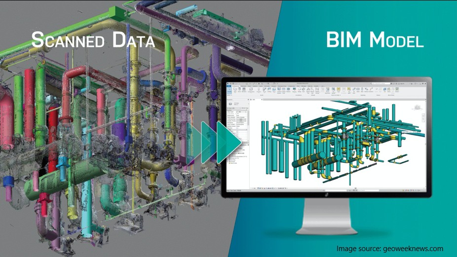
- Point Cloud Processing: From Heavy Data to Intelligent Models
Point clouds used to be unwieldy — massive files that slowed down BIM workflows. ReCap Pro 2026 changes that:
- Scan‑to‑Mesh reduces file size by up to 97%
- Surfaces are automatically segmented and classified
- Meshes can be edited, refined, and organised directly in ReCap
- Revit integration enables one-click conversion to families and elements
This shift turns raw data into structured, BIM-ready geometry.
Why the Scan‑to‑Mesh Workflow Is Revolutionary
- From Raw Data to Usable Models
Traditional point clouds are detailed but difficult to work with. Intelligent meshing transforms them into lightweight, structured surfaces that plug directly into BIM workflows.
- Local Processing Power
ReCap 2026 performs mesh generation locally — no cloud credits, no upload delays, no bandwidth issues. Teams maintain full control of their data.
- Classification and Editing
Floors, walls, ceilings, structural elements, and site features can be individually selected, tagged, and exported for modelling.
- Direct Revit Integration
The new plugin closes the gap between capture and modelling, enabling faster, more accurate as-built creation.
Why Accurate As-Built Data Matters More Than Ever
The construction industry is experiencing a surge in:
- Renovations
- Retrofits
- Adaptive reuse
- Maintenance-driven upgrades
These projects depend on accurate, reliable as-built information.
Reality capture provides:
- Verified dimensions
- True site conditions
- Early clash detection
- Reduced rework
- Better coordination for MEP and structural systems
For retrofit‑heavy markets, this accuracy is not a luxury — it’s essential.
Tools Driving the Process: Laser Scanning, LiDAR & Drone Capture
3D Laser Scanning
Laser scanners capture millions of points to create dense, highly accurate point clouds. These datasets form the backbone of BIM modelling, replacing manual measurements and outdated drawings.
LiDAR
Mounted on drones, vehicles, or handheld devices, LiDAR captures large areas quickly and with exceptional precision. It excels in:
- Topographical surveys
- Industrial sites
- Infrastructure corridors
- Complex terrain
Drone Photogrammetry
High-resolution imagery combined with AI-driven photogrammetry produces detailed 3D models ideal for planning, inspections, and progress tracking.
Together, these technologies create a complete digital representation of the built environment.
The Modern Scan‑to‑BIM Workflow
- Capture reality
- Process in ReCap
- Insert into Revit
- Establish coordinates
- Create levels
- Model with purpose
- Document accurately
When professionals master this pipeline, they unlock a new dimension of BIM — one grounded in real-world data and capable of supporting every stage of a building’s lifecycle.
The Bottom Line
Reality capture in 2026 is no longer just about scanning. It’s about connecting the physical and digital worlds with unprecedented accuracy and speed.
As the industry leans heavily into retrofits, upgrades, and lifecycle management, the ability to turn point clouds into intelligent BIM models is becoming one of the most valuable construction skills.
Testimonials
Thank you for all your efforts on our projects; they have been an invaluable contribution to their success. We look forward to working with you on future projects.
Ian Ferguson MPM Group
Jess and Karl at Draftech were amazing. The communication from the start was prompt, and the entire process was extremely easy. We needed their knowledge on Air Schematics, and they had made one up for our buildings that we service. Thanks so much, and we will be using you guys in the future. Cheers, Air Control Australia.
Greg Colebrook AirControl Australia
With Draftech’s thorough understanding of building services modelling and close attention to detail, Forth has been afforded the opportunity to outsource some of our BIM projects with absolute confidence in the accuracy of the final product.
Gary Murdoch Forth Consulting
Very professional and efficient organization. Delivered a great product to a tight deadline.
ACE Power
Karl and the team are very professional and have a vast knowledge of BIM coordination.
Dwayne Willaims Babinda Electrics
We had multiple large projects with tight deadlines and needed a company we could trust. The teams delivery, attention to detail and understanding of what is being designed is always executed to a high standard.
Martin O’Donovan Envar Engineers
Draftech offered a flexible and reliable approach to working collaboratively with our team. They met our expectations and quality requirements and also offered up new ideas.
Draftech have proven to be a valuable and trustworthy resource and we will continue to work with Draftech on other projects.
Simon Marsden Umow Lai
Draftech is different from others in the professionalism and features they provide.
The ability to walk through projects in real time online provides invaluable insight into problem areas and helps provide an efficient resolution on the spot without many phone calls, emails and the necessity for us to paw through countless drawings to understand the issues.
Todd Morris Manager - Air mech
Draftech were put forward to FIP Electrical as the solution to Coordinate, Model, carry out clash detection, provide Electrical Services Shop Drawings, as built documentation and completed electrical model.
Simon Thorpe FIP Electrical
In close collaboration Draftech set up all our systems and model deliverables. In this process Draftech have proven to be a valuable resource for us and demonstrated commitment, understanding and professionalism.
David Skelley DJCoalition
Draftech’s attention to detail and proactive nature throughout the project assisted us in identifying issues before becoming evident on site, saving us both time and unexpected costs.
Matt Payne PJM Engineering Services
They delivered very high quality Revit models and associated 2D documentation at key milestones, working to a tight budget and in strict accordance with the Architects’ BIM requirements.
Peter Thomas Geoff Hesford
We found Draftech’s work to be of high standard and the team delivered exactly as agreed, in fact, when we considered the project complete, Draftech put further resources into the project as they were not satisfied.
John Johnson Beca
Engaging Draftech during design gave us the tools to make smart decisions.
Hansen Yuncken Design Manager - Michael Harkins
The drafting service is timely, reliable and fit for purpose for the built environment.
Peter Harvey Harvey Industries
Draftech stands apart from other drafting services that we have previously used in their attention to detail and ability to adapt to the individual client’s requirements.
Doug Holt McCaig Aircon
I can confidently recommend Draftech as a solid and reliable supplier, and experts in their field. I look forward to working with them again in the near future.
Chris Behan Norman Disney & Young
After seeing the benefits Draftech provided us on the Townsville Hospital Redevelopment we have set up a relationship with Draftech and intend to continue to use their BIM knowledge and skills for our future projects.
Brad Lund Energy Power Systems
Draftech has no competition as they are in a class of their own.
John Boyes Babinda Electrics
Draftech Developments Drafting and Design Capabilities, in conjunction with their outstanding level of Client service and support has provided great solutions to our engineering and Drafting Design portions within our Gorgon Barrow Island Project.
Aaron Hazelton Applied Electro Systems Pty Ltd
Draftech set up necessary systems and workflows very quickly, but also setup auditable estimating and weekly cost tracking processes that we utilised, requiring little maintenance.
TOM PURDON MPM GROUP